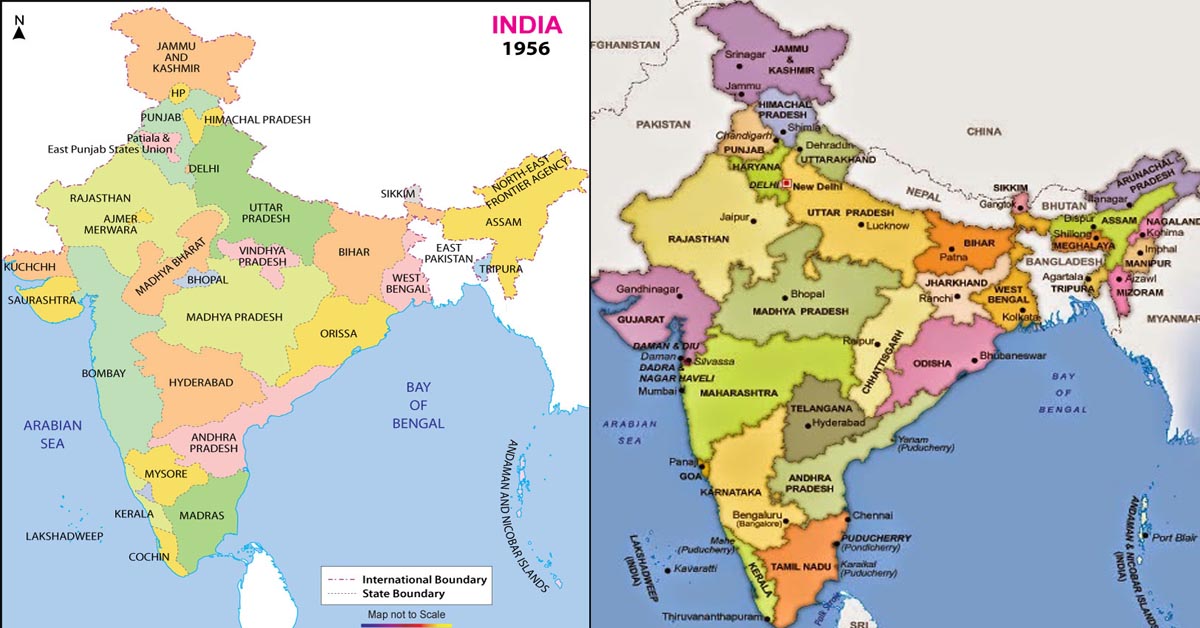
During British period India was divided into administrative units of Provinces (or Presidencies) and Princely states. Provinces were those units which were governed directly by British.
Princely stated were those units which were conquered/annexed by the policy of Subsidiary Alliance and the local king loyal to British was given the autonomy to rule the state. The powers and the authority of the local king were very limited and the administration was virtually in the hands of British.
At the time of independence in 1947, there were 11 Provinces and numerous (say 562) Princely states. Few of the main important provinces post independence are – Bombay, Madras, Bengal, Assam and United Province. Some of the princely states were quite big such as – Kashmir, Mysore, and Hyderabad while some were very small like Junagadh, Udaipur, Aundh, and Cochin.
Also Read: Republic Day Special: Indian Biryani’s `Unity in Diversity’- 7 different types of Biryanis
After independence, the British dissolved the treaty relations with the Princely states giving them the right to either accede to India or to Pakistan or remain neutral. Most of the states acceded to India and some to Pakistan. Jammu and Kashmir, Hyderabad and Bhutan choose to remain independent.
Hyderabad was annexed to India by armed intervention.
After 1947 most of the princely states were integrated into existing provinces while others organized to new provinces. Rajputana, Himachal Pradesh, Madhya Bharat and Vindhya Pradesh were made by integrating multiple princely states.
Mysore, Hyderabad, Bhopal, and Bilaspur were turned to new Provinces from princely states.
States and Union Territories Reorganization Act, 1956
This act was a major instrument which shaped the boundaries of States and Territories after independence. Some of the important outcomes of this act were
Andhra Pradesh – Andhra state was merged with a telugu speaking area of Hyderabad State (present Telangana) to create Andhra Pradesh.
Bombay State – the state was enlarged by adding the area of Saurashtra and Kutch, Nagpur division of Madhya Pradesh, Marathwada region of Hyderabad.
Kerala State – formed by the merger of Travancore state with Malabar district of Madras state.
Madhya Pradesh – was formed by merging Madhya Bharat province, Vindhya Pradesh, and Bhopal state.
Madras State – Malabar district was given to Kerala state, Laccadive, Minicoy and Amindivi islands separated out to form new territory (later renamed as Lakshadweep Islands in 1973)
Mysore State – enlarged by the addition of Coorg state and western Hyderabad state. It was renamed later as Karnataka in 1973.
Punjab State – enlarged by addition of Patiala and East Punjab States Union
Rajasthan State – enlarged by adding Ajmer state and parts of Madhya Pradesh and Bombay state.
Union Territories (6 No) – Himachal Pradesh, Andaman & Nicobar Islands, Delhi, Laccadive, Minicoy & Amindivi islands, Manipur and Tripura.
Present Scenario of States and Union Territories
India is a union consisting of 29 states and 7 territories. The states and territories are further divided into districts which in turn are divided into smaller administrative units like Tehsil, Taluka or Mandals.

Post Your Comments