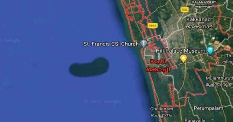
In a fascinating development, Google Map has recently detected a possible bean-shaped underwater island in the Arabian Sea near Kochi, which has become a matter of curiosity among everyone.
The satellite image which showed the mysterious island was first noticed out by the Chellanam Karshika Tourism Development Society. The President Advocate KX Julappan posted a screenshot of Google Map showing the island-like structure on Facebook.
The organization later informed the Kerala University of Fisheries and Ocean Studies (KUFOS) about the latest discovery.
What has confused many is that there is no visible land or structure at the spot, whereas according to Google Maps, the bean-shaped island could be 8 km long and 3.5 km wide.
The officials at KUFOS are planning to investigate the matter further.
‘Looking at the Google Map, this looks like any other underwater island that we see across the globe. There have been similar observations, and there is a specific shape also for this. But we don’t know what it is made of whether it is sand or clay and whether it is distributed regularly. We can only find out that through a proper investigation. Only after that, we can say anything concrete about this,’Vice Chancellor of KUFOS, K Riji John said.
John added that the members of the fishing community have raised doubts whether this formation is the result of dredging by the Cochin Port.
‘We have to check this possibility too. Normally, due to factors like underwater current, littoral drift, processes like accretion (coastal sediment returning to shore), or erosion of coast, are observed. In Kerala itself, towards the south region, there is the problem of erosion, while in areas like Vypeen (in Ernakulam district), kms-long accretion is observed. We cannot exactly say whether this phenomenon is also due to the same reason,’ he further added.

Post Your Comments