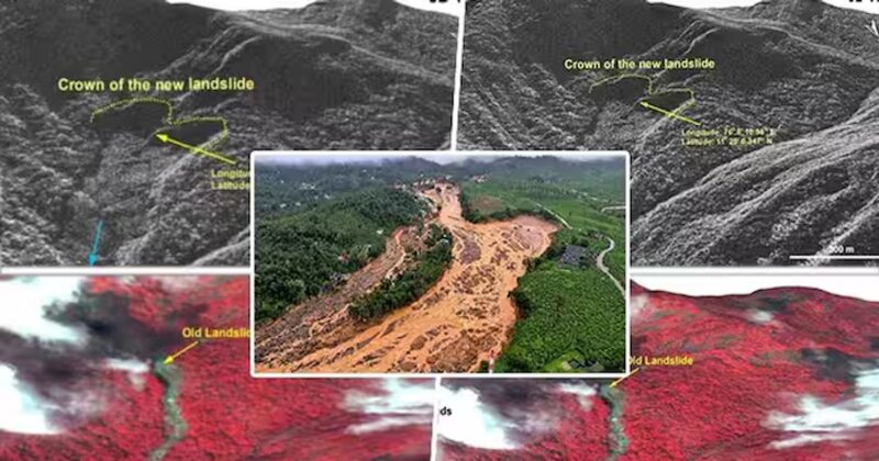
Kerala’s Wayanad district recently faced catastrophic landslides, resulting in over 300 deaths and at least 200 injuries, while devastating approximately 86,000 square meters of land. The National Remote Sensing Centre (NRSC), part of the Indian Space Research Organisation (ISRO), utilized high-resolution satellite imagery to document the damage. The landslides, originating from a 1,550-meter altitude near Chooralmala town, led to an 8-kilometer debris flow along the Mundakkai river, severely impacting towns, homes, and infrastructure. ISRO’s Risat and Cartosat-3 satellites provided before-and-after images, revealing significant changes in the landscape, including the widened river and breaches in its banks.
The NRSC’s detailed assessment indicated that the heavy rainfall around Chooralmala triggered the massive debris flow. Using Risat’s synthetic aperture radar (SAR) images, they mapped the 8-kilometer debris flow from its origin to the end zone, noting the reactivation of an older landslide at the crown zone. The debris flow not only widened the Mundakkai river but also caused substantial damage to properties along its banks. This comprehensive satellite-based evaluation underscores the significant destruction caused by the landslides.
In response to such disasters, NRSC scientists have innovated a rapid landslide detection method using satellite imagery and deep learning techniques. Their new model, DeepLabV3+, enhances regional mapping efficiency, crucial for disaster response. This method has been effectively tested across various Indian states, providing timely data for disaster management. Historically, ISRO’s Landslide Atlas of India, released in February 2023, identified Wayanad as highly vulnerable. The recent landslide tragedy highlights the necessity for ongoing monitoring and preparedness in such prone areas, with technological advancements offering better disaster management and intervention strategies.

Post Your Comments